The Louisiana Landmarks Society recently released its annual list of New Orleans’ nine most endangered historic sites in New Orleans.
Established in 1950, Louisiana Landmarks Society is one of the state’s oldest nonprofit preservation organizations, whose mission is to promote historic preservation through education, advocacy and operation of the Pitot House. The Society’s goal with this list is to make the public aware of the historic places so they can be saved, along with publicity for historic sites, advocacy for historic preservation, preservation education, and supporting proactive preservation efforts.
Check out the full list for 2017 below (and check out their list from 2015 too).

Image via louisianalandmarks.org
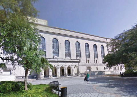
1. Historic Buildings in Louis Armstrong Park
LOCATION: 701 N. Rampart St.
THREAT: Demolition by Neglect
The National Park Service (NPS), FEMA, and the City of New Orleans play a part in the deterioration of the historic buildings in Louis Armstrong Park, including the Municipal Auditorium and the NPS Jazz Complex’s historic structures: Perseverance Hall, Caretaker’s Residence, Rabassa-DePouilly House, Reimann House and the Breezeway Building. Twelve years after Katrina, the City remains embroiled in negotiations with FEMA on funds to restore the Municipal Auditorium. Though the City recently secured the building to stop intruders, significant problems continue, such as holes in the roof that allow interior deterioration. The NPS Jazz Complex’s five historic structures in the park also suffer from neglect. The NPS lacks adequate funding, with a backlog of $12B in deferred maintenance projects nationwide. Congress should dedicate funding to maintain our national parks

Image via louisianalandmarks.org
2. Industrial Canal Communities
LOCATION: Lower Mississippi River – Industrial Canal
THREAT: Community Destabilization and Environmental Impacts
Still recovering from the levee breach after Katrina, the Ninth Ward and St. Bernard neighborhoods are now threatened by a 13-year infrastructure replacement project by the Corps of Engineers that includes the demolition of the 1921 Inner Harbor Navigation Canal (IHNC) Lock and St. Claude Bridge. Impacts to historic neighborhoods will be significant: dredging and transporting toxic materials, constructing new 24-foot flood walls, and destabilizing complex soils at the intersection of the IHNC and River – yet, questions go unanswered. Added to these are traffic and bridge impairments for Orleans and St. Bernard parishes, an outdated environmental impact statement (1997), safety concerns, damage to buildings, resident relocations, reduced property values, and economic stagnation. The project benefits and economics are speculative, engineering vague, and adverse impacts abundant.

Image via louisianalandmarks.org
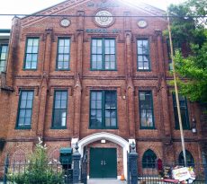
3. Israel M. Augustine School
LOCATION: 425 S. Broad St.
THREAT: Demolition by Neglect
The Spanish Colonial revival entry to Israel M. Augustine School presides over Broad Street near its intersection with Tulane Avenue. The balconette, escutcheons and red tile were added in 1927 to the circa 1913 building. Noted municipal architect E. A. Christy oversaw both the design and renovations of the school, originally named Samuel J. Peters. Today, the windows are shielded by metallic coverings installed when the Orleans Parish School Board opted to “mothball” the building post-Katrina. Hidden inside is one-of-a-kind artwork commissioned in 1931 by the Works Progress Administration, designed by Tulane watercolor instructor Leslie Powell and completed by Claire Silber. The series of thematic historic murals representing industry, power, finance, communication and transportation survived Katrina flooding and await restoration.

Image via louisianalandmarks.org
4. French Quarter Street Grid
LOCATION: 100-700 Blocks of Bourbon St.
THREAT: Loss of Historic French Quarter Grid
In 1721, the French engineer Adrien de Pauger arrived in the little settlement on the banks of the Mississippi River, then consisting of a few huts. Soon after, he drew a plan to impose order on this colonial outpost, using the grid pattern that dated back to Roman times. This “French Quarter Grid” has remained intact for almost three centuries, creating fluidity within this old neighborhood. This historic layout now is threatened by the “Citywide Security Plan,” which would close seven Bourbon Street blocks to vehicular traffic round-the-clock, even at intersections. The impact would be felt throughout the district, essentially stopping the flow of traffic and vitality in this living community. Temporary bollards may address safety concerns.

Image via louisianalandmarks.org
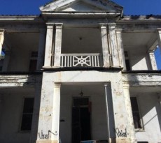
5. Oretha Castle Haley Elementary
LOCATION: 2515 N. Robertson St.
THREAT: Full Demolition
The former Charles E. Gayarre Elementary in the heart of the St. Roch neighborhood has sat vacant since the levee breach after Katrina inundated it with seven feet of floodwater. Built in 1921 by noted civic architect E. A. Christy in the early 20th century Mediterranean revival style, this three-story stucco and Spanish tile structure was auctioned as surplus school board property in 2013. Three years later, the owners applied for a full demolition permit to replace the building with a commercial “strip mall” development. The City Council denied that request in December 2016, encouraging adaptive reuse. The owners have since filed an appeal of that decision with the Civil District Court, continuing the risk for demolition.

Image via louisianalandmarks.org
6. Milneburg Lighthouse
LOCATION: UNO, Elysian Fields and Lake Pontchartrain
THREAT: Demolition by Neglect
The Port Pontchartrain Lighthouse is the only remnant of the once vibrant 1830’s Milneburg port town and fishing village. This 1855 masonry structure replaced an original 1839 wooden lighthouse and remained in service until 1929. Originally 3000 ft into Lake Pontchartrain, it now sits dry on reclaimed land. Between 1939 and 1983 it was maintained by the Pontchartrain Beach Park development, featured on their midway. Acquiring the lighthouse in 1991 for its Research and Technology Center, the University of New Orleans assured its preservation. This has not happened. The bricks of the building are suffering major mortar loss, and vegetation appears in cracks. Much of the original ironwork is missing. The property is significant for its 159 year role in New Orleans history.

Image via louisianalandmarks.org
7. Luling Mansion
LOCATION: 1436 Leda St.
THREAT: Demolition by Neglect
The colossal mansion at 1438 Leda Street sits hidden from Esplanade Avenue. Originally sited on 30 acres, it was designed by James Gallier, Jr. in 1865 as a 22 room residence for cotton merchant Florence Luling. In 1871 Luling sold it to the Louisiana Jockey Club (1871-1905). Converted into apartments in 1934, it has been owned by the same family since 1950. The mansion progressively displays visible water damage and decay of its wooden brackets, soffit and eaves from lack of basic maintenance. The original wooden balcony balustrades were insensitively replaced many years ago with one-sided aluminum castings. If these current wooden elements are not cared for, they too may be lost, further diminishing this grand, Renaissance palazzo-style landmark.

Image via louisianalandmarks.org
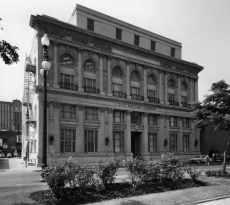
8. St. Claude Pharmaceutical Building
LOCATION: 2337 St. Claude Ave.
THREAT: Demolition by Neglect
An eagle still stands guard above the doorway to the neoclassical building designed in 1926 by eminent architect Emile Weil as the St. Roch Market Branch of Whitney Bank. Ornate capitals, embellished with urns, top the pilasters, but below graffiti scars the exterior at street level. Rot threatens the large multistory windows, decades of air pollution stain the cornice, and stone masonry is deteriorating. Home for decades to the Louisiana State Pharmaceutical Association, the building more recently served as an art studio. As of now, the commercial renaissance along St. Claude Ave. has bypassed this handsome structure, but the success of nearby adaptive reuse projects like St. Roch Market and the New Orleans Healing Center point to its latent potential.

Image via louisianalandmarks.org
9. 20th Century Service Station
LOCATION: 3420 Washington Ave.
THREAT: Demolition by Neglect
Early in the 20th century a new demand arose from the mass production of the automobile, the need for neighborhood fueling stations. Built for the Gulf Oil company, circa 1930, this early filling station is a rare example of transitional design from Craftsman style toward a more contemporary, Prairie School style, exemplified by its large cantilevered canopy supported on a single masonry column. Blighted and neglected, it stands decaying and overgrown with vegetation; yet it can be saved. Retaining its unique original green glazed tiles, unpainted masonry walls, original wood windows and broad canopy with details intact, if restored, it will provide a window into the early 20th century era of mobility and convenience in New Orleans.
about the author: CSB Staff
Related Posts
-
Louisiana Landmarks Releases 2019’s List of Most Endangered Historic Properties
-
List of New Orleans’ Nine Most Endangered Historic Sites Released
-
These Are The Best Historic Redevelopment Projects of 2014


What has happened???!!! Instead of preserving the classic elements of rich vivid living history that is the Belle Nouvelle Orleans as these buildings entail- petty muttonheads posing as stewards of governing kowtow to hysterical political correctthink and shred the remnants of art cast and carved to honor those whose valor and dignity rose to fight for their heartfelt duty. I see what is in store architecturally in the name of progress for my once beloved city and I am repulsed. Lowest bid on aesthetics, guaranteed! Mediocrity the worst blight.